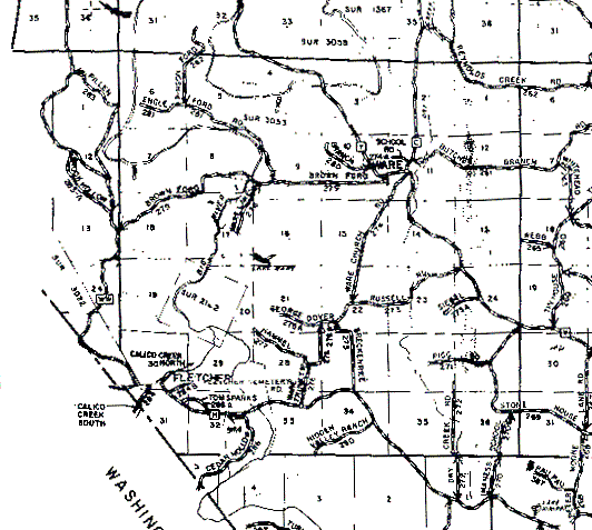
T40N,R3E is just about centered in the image. Its northern and southern boundaries are the first solid line from the top and bottom of the map, respectively. The eastern and western boundaries are the first solid lines vertical lines from the right and left edges of the map, respectively.
The small portion of T40N,R2E in Jefferson County is the tract immediately to the west of T40N,R3E that's missing a western boundary. That part was missing from the map I scanned, unfortunately.
T40N,R3E holds what we believe to be the first farm owned by our great-grandfather, George W PIERCE. It was described as "The East one-half of the Northwest quarter of Section 23 of Township 40 North of Range 3 East". The short north-south section of Russell Rd in section 23 runs through what looks to be just about the middle of that 80 acre tract. This land was originally registered with the (then) General Land Office by Michael MCKEE on May 10, 1824. We now have the original deed from the GLO, which was presumably given by MCKEE to PIERCE when the latter purchased the land. The year of this transaction is unknown, but we believe it was not later than 1850. Our father, Wayne Varney PIERCE, believed this to be the original farm in Missouri of our branch of the PIERCEs. However, we have recently discovered that on October 4, 1842 George W's father, Washington G PIERCE, purchased 80 acres from Mrs S SCAGGS (widow of Mr I SCAGGS) in what looks like (the document is hard to read) sections 28 and 29, T41N,R3E.