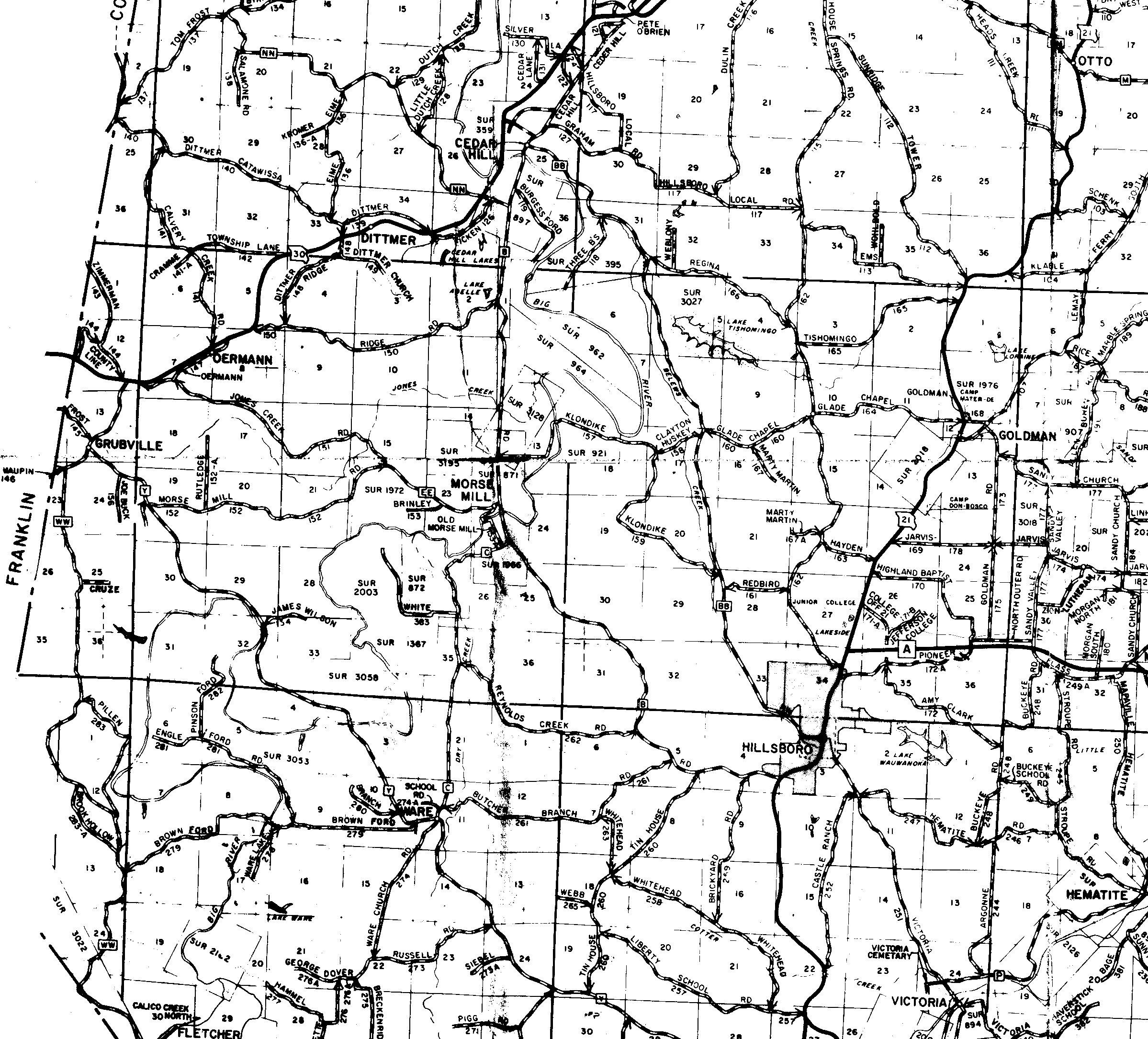
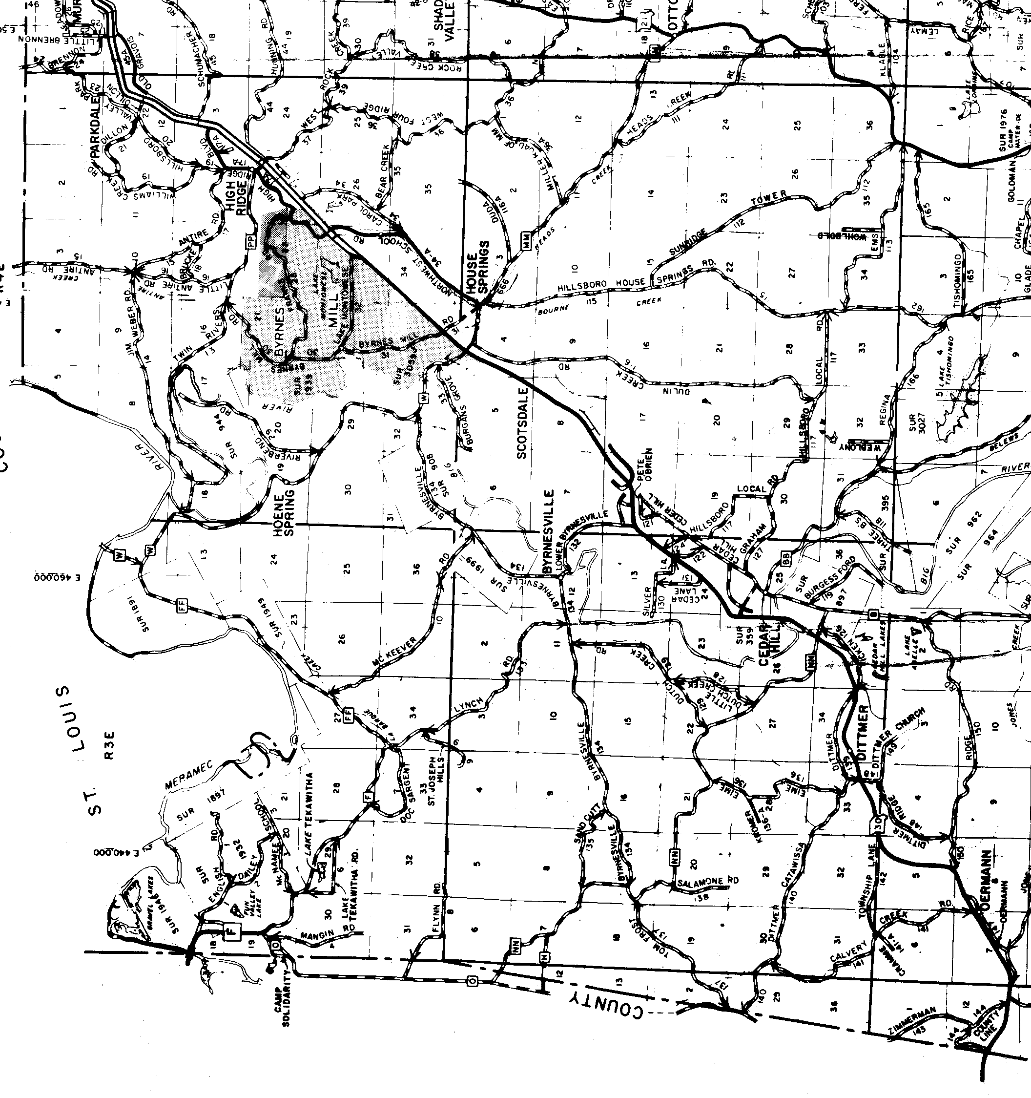
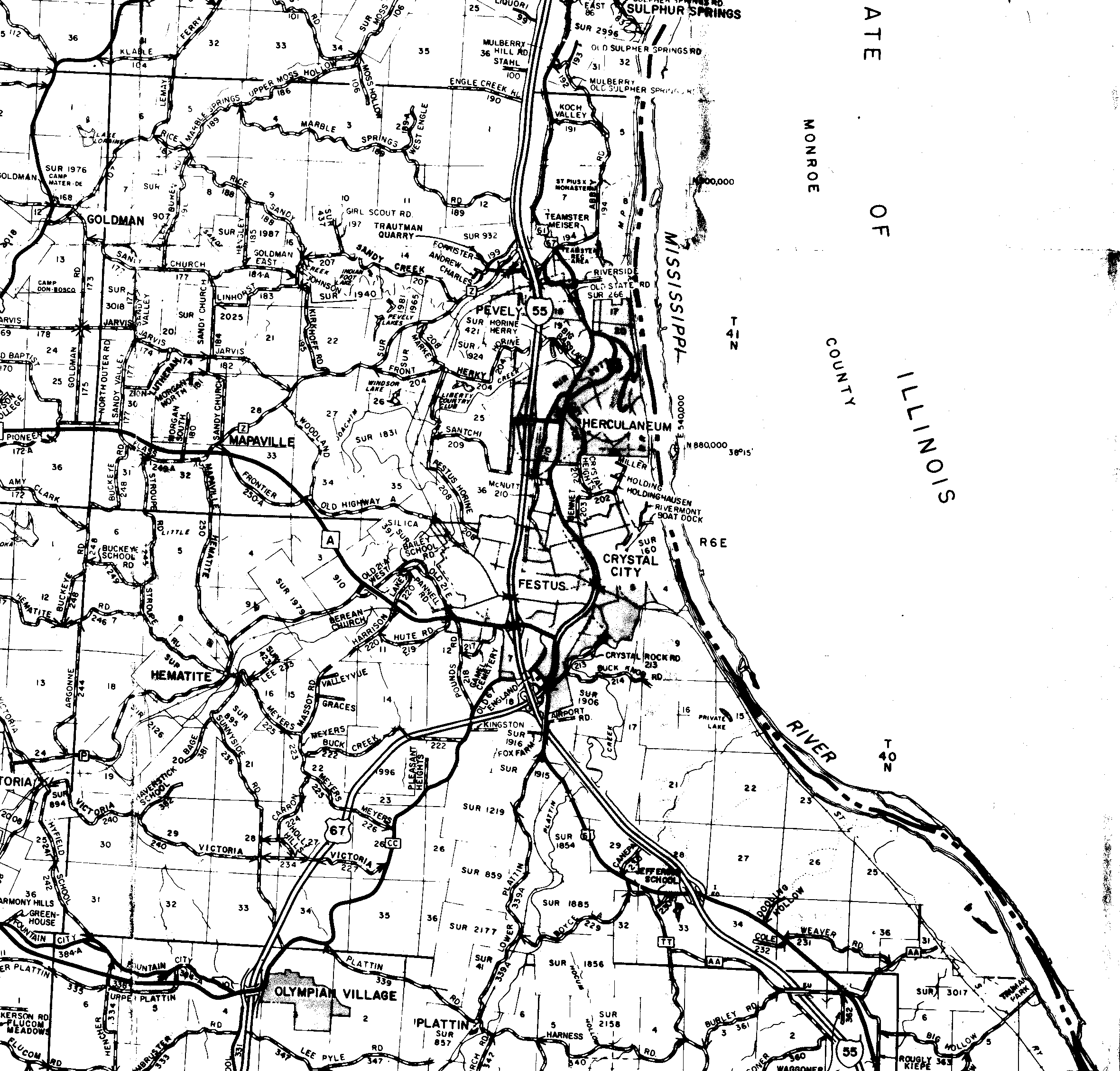
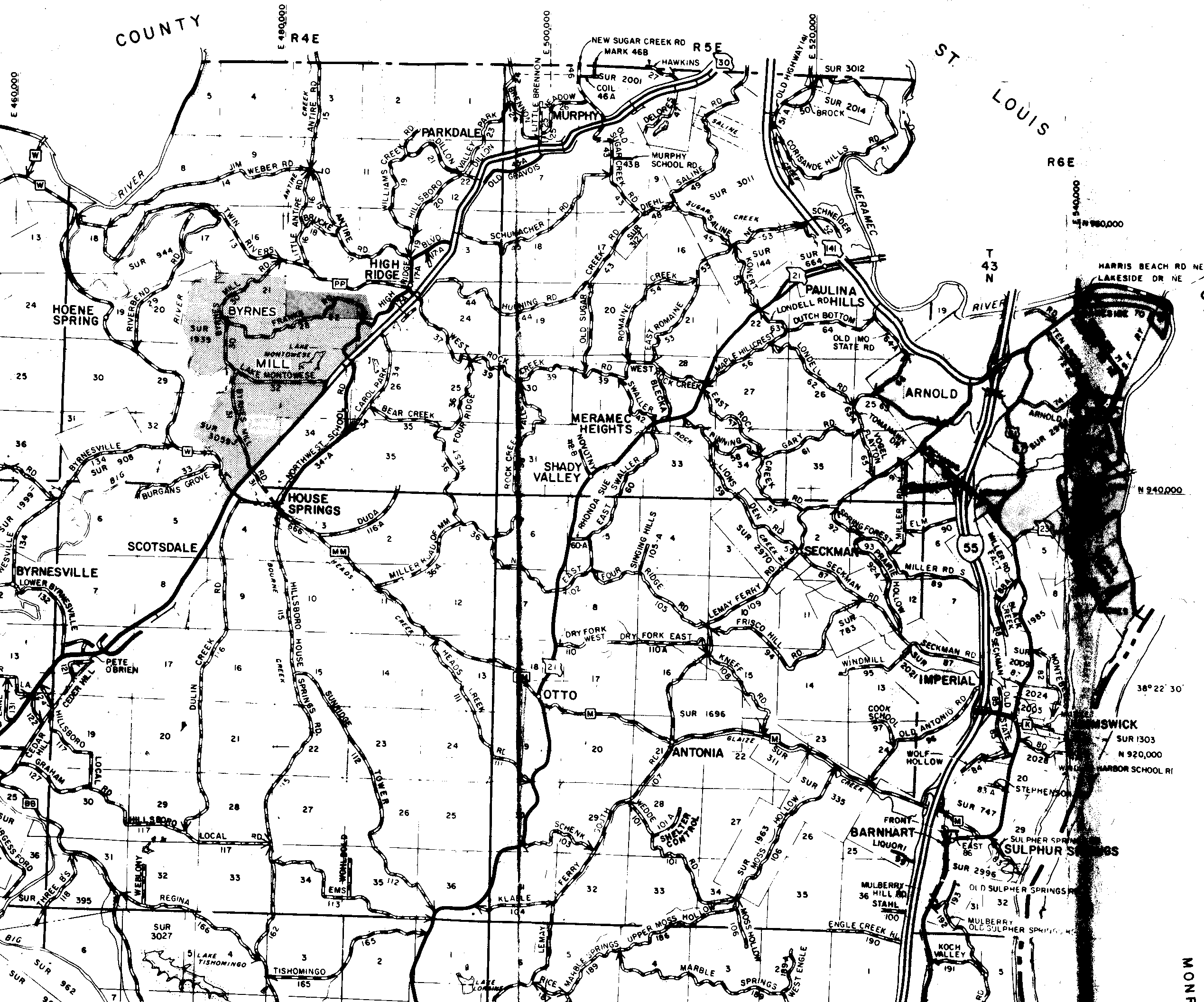
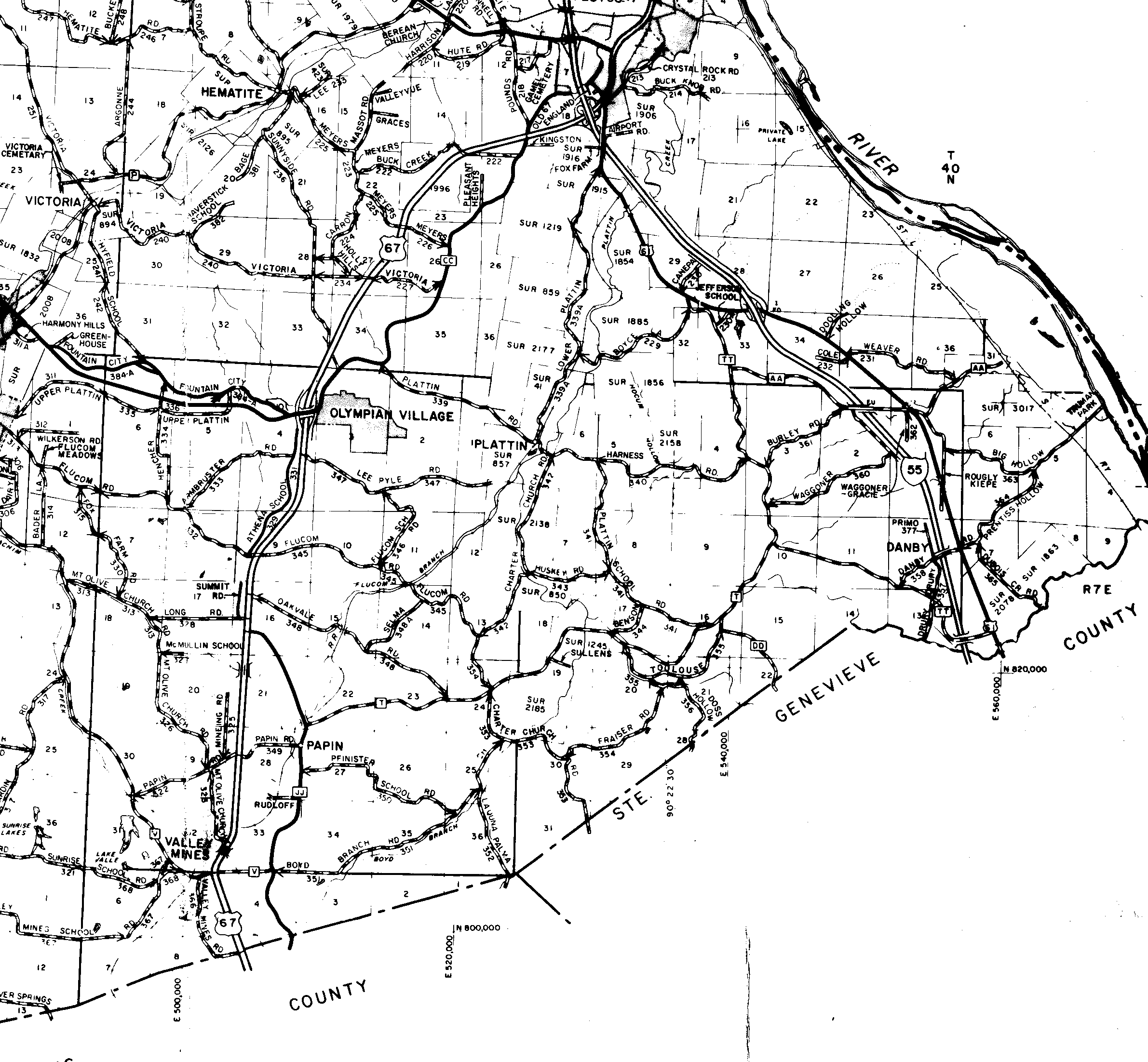
The images linked off of this page show various views of the Federal Township and Range System survey of Jefferson County, Missouri. I have provided a brief summary at this link.
The map used for these images was most kindly provided by Mona Houser. Further information about how these images were created and what they show is provided at this link. I will, however, apologize here for the quality of the images. Ms Houser's map was quite clear, and the original scans are actually very good. In reducing the originals to a manageable size, I lost quite a bit of their clarity. In the hopes that someone else may have the skills to do a better job, a link to the originals is provided at the bottom of this page.
John W Pierce - R2 Systems, San Diego, California - December 12, 1999
Link to Survey-to-Political Township Image Map
The above link goes to an image with "clickable" regions that shows the (current, I think) political townships overlayed on the survey townships. This is a 273 kilobyte image, and should take about 40 seconds to a minute to download with a 56Kb modem (if the network isn't too slow). It will start up in a new browser window. Clicking on the various survey townships brings up the same pages as the links under "Individual Township Maps" below.
Each link will open a new browser window showing a page containing map of a survey township, or possibly parts of two townships; that page will contain information about the area it covers. The grid is laid out in the north-south, east-west order in which the survey townships occur in the county. Some townships that are only partially in Jefferson County at its "edges" do not have links (e.g., "T42N R2E", "T38N R4E"). Their maps are included in the map for the adjacent township to the east (for Range 2 East), west (for Ranges 6 and 7 East), or north (for Township 38 North). The images range from 25 kilobytes to 78 kilobytes in size, and average around 50 kilobytes.
| Range | |||||||
| Township | 2 East | 3 East | 4 East | 5 East | 6 East | 7 East | |
| 43 North | T43N R3E |
T43N R4E |
T43N R5E |
T43N R6E |
|||
| 42 North | T42N R2E |
T42N R3E |
T42N R4E |
T42N R5E |
T42N R6E |
||
| 41 North | T41N R2E |
T41N R3E |
T41N R4E |
T41N R5E |
T41N R6E |
||
| 40 North | T40N R2E |
T40N R3E |
T40N R4E |
T40N R5E |
T40N R6E |
T40N R7E |
|
| 39 North | T39N R3E |
T39N R4E |
T39N R5E |
T39N R6E |
T39N R7E |
||
| 38 North | T38N R4E |
T38N R5E |
|||||
These maps show the various regions of the county with two to four townships on each map. There is quite a bit of overlap between the maps. The images are about 50 kilobytes each, and each map will come up in a new browser window.
| Northwest | Northeast | |
| Central - West | Central - East | |
| Southwest | Southeast |
The link above goes to a full map of the county. This is a moderately large image (542 kilobytes), and will probably take a couple of minutes to download with a 56Kb modem. Also, some browsers won't render it correctly, or the rendering will "break up" when you scroll the browser window. It is probably best viewed by downloading it to your own computer and then using a graphics program to see it (Microsoft Photo Editor, Adobe PhotoShop, etc).
The following are the original map scans, with file names
that indicate the area covered. For example, the name
4e40n-3e39n.gif indicates that
the image covers a square that T40N,R4E in the upper right (northeast)
corner and T39N,R3E in the lower left (southwest) corner. (There was
a reason for using that convention - it turned out to be a dumb reason,
but there really was one.)
| File Name | Upper Right Corner | Lower Left Corner | Size |
|---|---|---|---|
| 4e40n-3e39n.gif | T40N,R4E | T39N,R3E | 174KB |
| 4e41n-3e41n.gif | T41N,R4E | T41N,R3E | 203KB |
| 4e43n-3e42n.gif | T43N,R4E | T42N,R3E | 163KB |
| 5e41n-5e40n.gif | T41N,R5E | T40N,R5E | 206KB |
| 5e43n-4e42n.gif | T43N,R5E | T42N,R4E | 219KB |
| 7e39n-5e39n.gif | T39N,R7E | T39N,R5E | 179KB |